Comments will only be accepted until 5pm on Monday November 16th.
The Council has focussed the subject of consultation on whether the plans are sound according to the four tests of soundness. So while you might want to (and should!) make general comments, the council wants you to focus on arguments that will carry weight in front of an inspector. The arguments can be technical.
Help is at hand, though. If you join us at Wellington Hill Residents’ Association on 10th November between 17:30 and 21:00 we’ll clue you in on how to object and help you write your response.
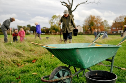
Braving what was threatening to look like some nasty weather, a steady stream of hardy planters assembled on the fields to plant daffodil bulbs for next spring. While the grass around the now somewhat ornamental dead trees was initially tough to get through, everyone developed their own technique, and planting in this area makes it easier for for the regular mowing to avoid the planting areas.
The sun managed to come out by the time we were finishing, just in time for some well-earned tea and excellent buns (thanks Georgia!), and the knowledge that next spring we’ll see a big splash of colour right in the central area of the fields.
Many thanks to those who stiffened their upper lip and joined us, and many thanks to Groundwork and their bulb bonanza Leeds programme. We’ve got something special to look forward to in spring!
All residents of Whinmoor, Wellington Hill and Red Halls are welcomed to come along to the Whinmoor Forum, Chaired by Cllr Peter Gruen. Highlights include a discussion on planning issues regarding future development around Whinmoor and Red Halls.
Come and speak to your ward councillors about plans for development in the area at the Wellington Hill Resident’s Association.
If you’re coming along, feel free to join the Facebook event.
The Council appears to have focussed the subject of consultation on whether the plans are sound according to the four tests of soundness. So while you might want to (and should!) make general comments, the council wants you to focus on arguments that will carry weight in front of an inspector.
Other drop-in sessions are available, but on 21st Oct, between 2pm and 7pm, planning officers will be available to talk you through the site allocations plan and how to respond.
This is your opportunity to talk to Leeds City Council planning officers about the nature of the consultation. Drop in!
The Council appears to have focussed the subject of consultation on whether the plans are sound according to the four tests of soundness. So while you might want to (and should!) make general comments, the council wants you to focus on arguments that will carry weight in front of an inspector. The arguments are necessarily technical. At first glance, it might look to you as if this is not for the faint of heart!
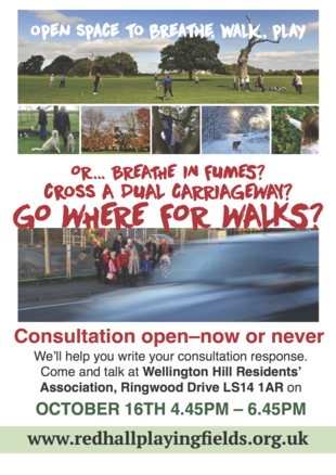
Help is at hand, though. If you join us at Wellington Hill Residents’ Association on 16th October between 16:45 and 18:45 we’ll clue you in on how to object and help you write your response.
Within a 20 min walk or a 5 minute walk to a bus stop offering a direct service at a 15 min frequency (or, where appropriate, 10 min walk to a rail station offering a 30 min frequency service)
In 2015:
Threeoutof five community admissions-policy primary schools closest to the fields were oversubscribed (they could not allocate all requested places)
One out of the five (Shadwell Primary School) could not allocate places for pupils for whom it was their nearest school
The one school with availability (Grange Farm primary) requires improvement and is not within the 20 minutes’ walking distance.
In short, there is no school that is not already oversubscribed – or worse, unable to provide places to all children for whom it is their nearest school – within the distances mandated by policy T2.
There is also no bus stop within 5 minutes’ walk offering a 15 minute service frequency to a major public transport interchange.
How this affected families in 2015
One girl living in the houses immediately to the south of the fields was allocated a school 3.6 miles away – over an hour’s walk – from her home.
One boy immediately to the south of the fields was allocated none of his parents’ five preferences – instead, he was allocated a religious school that was not his religion.
Another family living in the houses immediately to the south of the fields had been forced to send her son to a primary school in Wetherby since moving here in 2013. Because of this, they have recently moved away from Leeds.
Secondary schools
Secondary schools must be:
Within a 30 min direct walk or 5 min walk to a bus stop offering a 15 min service frequency to a major public transport interchange (or, where appropriate, 10 min walk to a rail station offering a 30 min frequency service).
There are no secondary schools that meet the walking criteria near to any edge of the fields. There is no bus stop within 5 minutes’ walk offering a 15 minute service frequency to a major public transport interchange.
always seek to secure high quality design and a good standard of amenity for all existing and future occupants of land and buildings
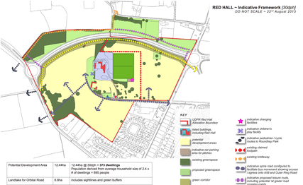
In a ward already deficient in green space, and in an area (East Leeds) that suffers from poor quality green space provision across all typologies, the plans take away valued communal green space directly opposite both an existing large settlement and the site of the Northern Quadrant (see figure, playing fields in far north-western corner). The Northern Quadrant, having planning permission, is soon to see 2000 new homes built. The site of the existing nurseries and a field to the south are set to see 300 new houses if plans go ahead. 50 houses are planned for the fields themselves.
2. Land of lesser environmental value not preferred
Allocations of land for development should prefer land of lesser environmental value
The fields are a partly natural green space with tree cover in one corner, mature trees dotted around, and mature trees and hedgerows at the periphery. Other sites in the so-called “green wedge” extending out from Leeds are of lesser value (being only fenced green fields) and are not publicly accessible, but have not been allocated due to:
Local preference to not bring forward sites to the east of Roundhay Park (1190, 1138, 3315A, 3315B, 4013, 2063 and for Wetherby Road to remain as a natural buffer.
Site 2062 – Red Hall Playing Fields – is also a site to the east of Roundhay Park. It is also on the same side of the A58 as all these other sites where “local preference” is for the A58 to be a “natural buffer”. Whose local preference was taken into account (particularly for site 2063), and why is ours not being? Could it be because Leeds City Council hopes to realise a large capital receipt by selling the fields to developers? (The short answer, it turns out, is yes)
3. Not encouraging multiple benefits from the use of land
promote mixed use developments, and encourage multiple benefits from the use of land in urban and rural areas, recognising that some open land can perform many functions (such as for wildlife, recreation, flood risk mitigation, carbon storage, or food production)
This land is currently serving four typologies-worth of green space duty: playing provision, natural green space, parks and gardens, and amenity space, given that little else is locally accessible. See the map and search for ‘2062’ – there’s nothing else round here. It also has a wet season, which currently serves to soak up surface water that otherwise would pose a run-off risk to surrounding properties. Areas with tree cover are home to a variety of wildlife.
4. Not conserving heritage assets
conserve heritage assets in a manner appropriate to their significance, so that they can be enjoyed for their contribution to the quality of life of this and future generations
No consideration we can find has been given to the preservation of the fields as the historic parkland to the grade II-listed Red Hall House.
The Town and Country Planning Act 1990 requires that “special regard” is given to the preservation of the setting of historic assets before an allocation is made. This is acknowledged in a 2013 site proforma – mirrored here when the Leeds site is down:
Redhall House to the west of this site is a Grade II Listed Building. There is a requirement in the 1990 Act that “special regard” should be had to the desirability of preserving Listed Buildings or their setting or any features of special architectural or historic interest which they possess. Consequently, before allocating this area, there would need to be some assesment of what contribution this currently undeveloped area makes to the signficance of this building and what effect its loss and subsequent development might have upon the significance of this asset. If allocated, development proposals would need to ensure that those elements which contribute to the significance of these assets (including their setting) are not likely to be harmed
We cannot find evidence of such regard.
5. Not delivering sufficient community facilities
take account of and support local strategies to improve health, social and cultural wellbeing for all, and deliver sufficient community and cultural facilities and services to meet local needs.
At ward level, we are already in deficit in five out of six typologies of green space. Locally, this is the single public amenity/common space in walking distance. Moving the majority of the fields to a different ward is unacceptable in both the NPPF and in Leeds’ own core strategy policy G3.
We are well below acceptable accessible green space standards in our ward. Even if the fields were to remain, building is going to push us further into unacceptable deficit. We should not be allocating these fields for development, as this would further exacerbate an already bad situation. We are already due to lose a large proportion of this land to the East Leeds Orbital Road. Let’s not make it any worse.
It appears Leeds’ response to this is to play down their own ward-based green space analysis, and that we should use Roundhay Park. Roundhay Park is not – in any typology for which it is used – within the accessibility distances called for in Core Strategy Policy G3. It’s also on the other side of a Ring Road with no crossing points, and no entrance on the side of the Ring Road. Into some woods.
To deliver the social, recreational and cultural facilities and services the community needs, planning policies and decisions should:
plan positively for the provision and use of shared space, community facilities (such as local shops, meeting places, sports venues, cultural buildings, public houses and places of worship) and other local services to enhance the sustainability of communities and residential environments;
guard against the unnecessary loss of valued facilities and services, particularly where this would reduce the community’s ability to meet its day-to-day needs;
For hundreds of houses east and west of the A58, this is the only amenity within walking distance.
We are about to see construction of the East Leeds Orbital Road (ELOR), which will leave this block of residential developments bounded by three major roads: the A58, the A6120 outer ring road, and ELOR.
Their planned reduction in size to accommodate 50 more houses when thousands of houses are being built both east and west of them reduces our ability to meet our day-to-day needs. There is an opportunity in this location to make a distinctive place that serves its residents well and includes Red Hall House as an historic centrepiece. That opportunity is being squandered.
ensure that established shops, facilities and services are able to develop and modernise in a way that is sustainable, and retained for the benefit of the community;
One planner has remarked to us that this is one of the least sustainable uses of land he has seen in the entire allocations process. We will be much less able to meet day-to-day needs surrounded by A-roads.
ensure an integrated approach to considering the location of housing, economic uses and community facilities and services.
This allocation can in no way be considered an “integrated approach”. For the sake of 50 houses, it utterly ignores the huge incoming developments to both its east (Northern Quadrant, 2000 houses) and west (soon-to-be-vacated brownfield Council nurseries and annexed greenfield, some hundreds of houses), and likewise pays no heed to the further deficits in green space into which this ward will be forced.
It is not possible to say how much green space will show up in compensatory form. When this land is sold, that will be left to developers, who, as councillors have already said, have the whip hand in terms of monetary and legal resources when it comes to winning planning appeals. The worry is that this part of Leeds will become another endless stretch of car-dependent houses with few facilities and little infrastructure.
Access to high quality open spaces and opportunities for sport and recreation can make an important contribution to the health and well-being of communities. Planning policies should be based on robust and up-to-date assessments of the needs for open space, sports and recreation facilities and opportunities for new provision. The assessments should identify specific needs and quantitative or qualitative deficits or surpluses of open space, sports and recreational facilities in the local area. Information gained from the assessments should be used to determine what open space, sports and recreational provision is required.
Our green space deficit and projected further fall should be all the evidence that is required to show that the retention of as much of this space as possible should be an absolute requirement. These fields are serving multiple purposes: they are our playing provision, our amenity space, our parks and gardens, and our natural green space. There is nothing in those latter three categories in the walkable distances defined in core strategy policy G3.
Existing open space, sports and recreational buildings and land, including playing fields, should not be built on unless:
an assessment has been undertaken which has clearly shown the open space, buildings or land to be surplus to requirements; or
We cannot find such an assessment.
the loss resulting from the proposed development would be replaced by equivalent or better provision in terms of quantity and quality in a suitable location; or
The planned replacement is not in the same ward; it would transfer hectares of publicly-accessible green space to the Harewood ward, which already enjoys a surplus; that new facility would not be near the majority of Red Hall / Whinmoor residents and would require a car journey to get to. It would also be sited adjacent to a cemetery. It seems scarcely appropriate that mourners, in their grief, might have the noise and robust language of Sunday League games happening next door to them, while Red Hall House, which houses a sporting body in the shape of the Rugby Football League – and whose pitches are used to train referees – will see a dual carriageway and housing.
the development is for alternative sports and recreational provision, the needs for which clearly outweigh the loss.
The development would be for more housing and a dual carriageway, with all the attendant traffic, pollution and noise that would bring.
In preparing plans to meet development needs, the aim should be to minimise pollution and other adverse effects on the local and natural environment. Plans should allocate land with the least environmental or amenity value, where consistent with other policies in this Framework.
As we state above, land of lesser amenity value is to be preserved. Adverse effects on air and noise will come from the 50mph dual carriageway East Leeds Orbital Road.
Planning policies and decisions should aim to:
[…]
identify and protect areas of tranquillity which have remained relatively undisturbed by noise and are prized for their recreational and amenity value for this reason.
Towards Red Hall House, the noise from the A58 is not particularly noticeable. Houses at that end have normal windows. However, new houses nearer the A58 are triple-glazed and have venting in different areas to prevent the ingress of noise. The plans to cut these fields in half with a dual carriageway – and further, only to dig that road to a metre’s depth – will destroy the quieter nature of the west of the fields and create 24-hour noise for everyone in the vicinity.
Local planning authorities should set out in their Local Plan a positive strategy for the conservation and enjoyment of the historic environment, including heritage assets most at risk through neglect, decay or other threats. In doing so, they should recognise that heritage assets are an irreplaceable resource and conserve them in a manner appropriate to their significance. In developing this strategy, local planning authorities should take into account:
the desirability of sustaining and enhancing the significance of heritage assets and putting them to viable uses consistent with their conservation;
the wider social, cultural, economic and environmental benefits that conservation of the historic environment can bring;
the desirability of new development making a positive contribution to local character and distinctiveness; and
opportunities to draw on the contribution made by the historic environment to the character of a place.
So far, as we have said, there has been no “special regard” given to Red Hall House or its setting according to the Town and Country Planning Act 1990. This allocation also runs counter to paragraph 126 of the NPPF.
The house was once a hunting lodge and the fields part of the house’s curtilage. There is long history here of sporting activity. The fields were sold to Leeds City Council in 1937, and while originally intended for a velodrome, they were used for many years for sporting activity – football, cricket and rugby. The house itself is now home to the Rugby Football League. Many residents local to the fields talk of their experiences growing up playing formal and informal games on the fields, and express shock at their potential loss.
The local character and distinctiveness here are bound up in the history of the house and its associated land for sporting endeavour and recreation. In allocating this site these are all factors Leeds City Council is choosing to overlook.
Earlier this year, we took a deputation to Leeds City Council’s main council meeting, calling for some commitment from Leeds City Council to protect Red Hall Playing Fields, given that it is a green space that serves all of our community’s Parks and Gardens, Amenity Green Space and Playing Provision needs.
The council’s full response is available. It now seems clear that the sale of the fields is intended to raise funds to:
Relocate the Leeds City Council nurseries to a new facility at Whinmoor Grange
Partially fund the East Leeds Orbital Road
We do not believe that depriving the local community of the only significant green space it has within walking distance is an acceptable way of funding the move of a nursery that wins awards in spite of its current location, nor is it an appropriate way to fund a road that will pollute the very space it intends to decimate.
Neither do we agree that Roundhay Park is within walking distance of most residents who use the fields – indeed, the response’s quoted distance of 0.66mi (1.02Km) is fanciful – and greater than Core Strategy policy requirements in any case.
Finally, we do not believe that the Council has recognised that these fields are not primarily serving the purpose of playing provision and are capable of being parks and gardens, amenity space and natural greenspace in addition to their stated use. They are for fitness training, dog-walking, kite-flying, informal football, cricket, rugby, blackberry-picking, shared community, running, playing, and living. They are a quieter space in an area soon to be bounded by three A-roads.
The response itself is inaccurate in many respects. Without reproducing the entire document, which you can also read in full, here are the points on which we disagree:
3.2 “Waterlogging” – don’t do yourselves down, council!
3.2 The land allocated for employment use extends to c.11 hectares with c.4 hectares of formal playing pitches within this. This area was previously laid out as 5 playing fields (4 football and 1 rugby league) and a 6 team changing block, but these have not been used since 2006, as a result of ongoing drainage issues that were proving too costly to address in a sustainable way. The playing fields remain in water-logged state for a large part of the year but remain capable of use for informal amenity purposes in dry periods.
The fields are now in use as amenity space all year round.
Following meetings between council officials and members of the Friends, the previously-unmaintained ditches have been cleaned out and the historic drainage system now keeps the fields drier for a much larger proportion of the year. Even when the fields are wet they can now only be described as “waterlogged” on the periphery of the A58 and in the area closest to Red Hall Lane. We use them all year. Wellington boots might well be required at times, but that can also be said of Roundhay Park.
Thanks, councillors and officers – you’ve done an excellent job in making the drainage situation better for everyone here without spending a ton of cash. Don’t do yourselves down.
2.3 We formed The Friends in response to a pre-planning document
2.3 The Council understands that the Friends of Red Hall Playing Fields group was formed in 2013 following the completion and occupation of a new build housing site on the southern edge of the playing field land, and the consultation undertaken by the Council on the Site Allocations Plan (Issues and Options June 2013), which proposed a housing allocation for the whole site including the playing fields.
No-one knew about the consultation until this document was published and we were taken by surprise by it due to one of our member’s subscriptions to Council notification systems.
3.9 That “long-standing” argument dissected
3.9 The proposition for residential development of the site rather than a business park reflects changes in national planning policy since 2006 that restrict the development of out-of-centre office development. It should also be noted that since the original allocation of the site for a business park, the housing needs of the city have grown significantly in scale, requiring all identified market areas of Leeds to have sufficient land identified to deliver 70,000 new homes by 2028.
The Council likes to use the phrase “long-standing formal development allocation” to say “but this site has always been allocated for development”, as if that decision is in any way relevant over two decades later. However, when it wants to respond to change itself – in this case changing the nature of that development – it does so, and refers to the change in scale of the housing needs of the city.
They’re right – things have changed. There will be 2000 new houses to the east and some hundreds of houses on the old nursery site and on the fields to the north and south of the fields. These were also factors not in play when the “long-standing” allocation was made. They only increase the local need for quality green space provision.
The fields themselves are to be allocated for 50 houses. This represents a mere 1% of the houses to be built in Crossgates and Whinmoor Ward alone.
They’re not going to tell you why this comparatively minuscule allocation is so important, though. It’s because the houses planned for building are to be £500K+ luxury homes – the sort of profit margin build over which developers salivate, and which represent a fat carrot they won’t ignore, while doing little to deal with that change in scale. Meaning that a road that benefits few people actually living here can be funded at the expense of those self-same residents.
In public hands since 1937
Even if you agreed with the 70,000 homes target – and we, like many, including the Office of National Statistics, who put the projected need at closer to 45,000 by 2028, don’t – it would be more appropriate to respond to this unprecedented surge in building by leaving adequate green space for these future residents rather than indulging in a fire sale of valued and valuable assets.
And if you really want to use the “long-standing” argument – well, Leeds City Council bought the land to use for sporting provision in 1937. These fields have been used for sport since the 19th century and possibly before. They have a history bound up with that of the house. A 20 year-old planning decision, by comparison, is of no historical value.
3.10 2013’s “Blink and you’ll miss it” Consultation
3.10 The principle of residential use across the whole of the Red Hall site was put forward in the Site Allocations (Issues & Options) consultation undertaken in June/July 2013 and is proposed as the allocated land use here through the Site Allocations Plan Publication Draft, with consultation on that plan to be undertaken
in the Autumn of this year.
Leeds City Council likes to pat itself on the back that very few comments objecting to the use of this land were received in 2013. However, nobody in the area knew about the consultation. One marketing manager at a meeting with councillors in January 2014 of around 50 residents (all of whom objected to the fields use) said that he “would have been fired” if he had failed to engage with his target audience in this way. A council officer at the same meeting told us that she had seen the bus adverts “Your city, your say” but couldn’t tell from this what they were for.
It is a stretch to equate a failure to engage with the electorate as being indicative of support for loss of amenity.
3.11 Sustainability appraisal scoring errors
3.11 The sustainability impacts of each of the proposed site allocations have been considered in relative terms across the city as a whole. As an existing development allocation Red Hall was assessed as a more sustainable location for development than many others, such as those that would have been in Green Belt or in previously unallocated locations.
There were mistakes made in the sustainability appraisal scoring that led to the allocation of the fields. Even if you charitably accept that the scoring was accurate (it wasn’t), the fields are in the top 3 least sustainable sites out of some 216 allocated for development across the city. If the errors were corrected, the fields would be the single least sustainable site allocated across Leeds.
3.12 Quantum of provision (or: you’re moving this ward’s green space to Harewood)
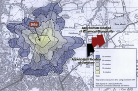
3.12 The playing fields have been considered in the green space analysis undertaken as part of the Site Allocations Plan and are assumed as being retained or re- provided so there is no overall impact on the quantum of provision. The green space analysis is undertaken at a ward level, as a proxy in the absence of a better alternative, but when assessing specific schemes is also appropriate to consider geographical proximity. Red Hall is in Crossgates & Whinmoor ward but is located at the boundary with two others and is close to Roundhay Park in the Roundhay Ward.
Roundhay Park is not within walking distance. It is not within the distance that is called for in Core Strategy Policy G3. Even if it were, it is over the other side of the Ring Road. That Ring Road has no crossing points. The side of the park facing the Ring Road is inaccessible as it is tree-lined. One must walk into the centre of Roundhay before even the entrance to the park becomes apparent.
When the playing fields are re-provided, they will be 30 minutes’ walk from their current location.
So while we accept that the relevance of the ward-based analysis may vary as you come to the borders of wards, we do not accept that walkable alternatives are already available. Nor will they become available with accessibility improvements. Which is to say nothing of how the decimation of these fields affects people in Red Hall, Whinmoor, and Shadwell.
3.13 No really, Roundhay Park is not accessible from here
3.13 In releasing the nursery and depot part of the site for development, this will become publically accessible with amenity green space, pedestrian and cycle routes designed in to connect with the wider green space network and Public Rights of Way extending into adjoining the countryside. Access through this part of the site will make Roundhay Park more accessible, the edge of it being 0.66 miles away in this direction – the park is currently 1.5 miles away via public highway.
Ah, walkability again. 0.66 miles is 1.06Km. It is not clear in this statement which part of Red Hall Playing Fields can be made to be 0.66 miles away from Roundhay Park. I’ve been sitting here with a measuring tool and a map and I can’t get myself into Roundhay Park from the charitable starting point of the south-westerly portion of the fields. I can just about get myself into the woods surrounding Roundhay Park (at least, were I able to fly) which is hardly a safe space for the young, the elderly, or women walking alone. Nonetheless, even if this somewhat fanciful distance could be achieved, it is still over the 720m distance called for in policy G3 for parks and gardens. It is over the 720m called for by natural green space. It is well over the 480m called for by amenity space.
In any case, the distance quoted is just that: fanciful. And does not take into account the needs of those in Shadwell, Whinmoor, or Red Hall.
Right now, people from these three areas can be on the fields relaxing in 1-10 minutes, just by walking. If you’re proposing that Roundhay Park should be where these people go, you’re on a different planet. That would be a 30 minute trek, even if you could cross the Ring Road safely. Would you send your children there? Or are you happy for them to play on the fields in plain sight? Would you suggest your 70 year-old father with a heart condition go for a quick walk there? Would you plan a walk there with a four year-old? Will you add the two hours round trip to your daily schedule when your dog needs her twice-a-day walk?
The council’s plan, if executed, is to reduce the local community’s ability to meet its day-to-day needs. Effectively saying “you can just use Roundhay Park” is little better than “let them eat cake”.
3.14 These aren’t just playing fields
3.14 The whole Red Hall site will comprise two proposed housing allocations – one for the current nursery and depot site and one for the Area currently in use as playing fields together with the ‘5 acre site’ to the north, which is currently used for storage and composting in association with the nursery.
We take no issue with the allocation of the nurseries – this is precisely the sort of brownfield re-use that is to be encouraged. As the deputation stated, we are only interested in the publicly-accessible portion of the site – the land that has been in public hands since 1937.
As the deputation said, one of our key issues is that we have little or no access to amenity green space, Parks and Gardens, or natural green space. These playing fields perform those functions too. The use of the fields is incredibly diverse: fitness training, informal sports, family picnics and activities, dog walking and training, extra-mural outings for the disabled, as an area of tranquillity (away from the A58), community engagement, kite flying, blackberry and apple picking.
3.15 Protection of the setting of the historic building
The fields as gardens/hunting area in 1851
3.15 The Listed Buildings and land in the ownership and operation of the Rugby Football League will remain unallocated for development.
This doesn’t help with the fact that the fields are the historic parkland to the house. They have been in use as such for more than 200 years, and no special regard for this has been given prior to allocation.
3.16 We really are using this space for more than just sports, you know
3.16 Any development of the site will be required to retain a single area of green space equivalent in size to at least two playing pitches so that re-provision of formal sports use can be made in response to identified need in the wider area. For any pitches not retained on site the provisions of NPPF para. 74 would apply.
There are thousands of new houses coming to the east. There are hundreds coming to the west. The fields as they stand are in use for activities mostly other than playing provision. If two pitches are all that is left, and are reinstated as formal playing pitches, we will not be able to use them for the diverse activities these fields currently support, due to both contention with formal activities and pitch wear (the fields might be waterlogged now, but try running around with a small child on them in the middle of February after much of a gruelling season).
This was a key point made by the deputation, and it has not been addressed.
3.17 Preservation of the house’s setting
3.17 Any development would also need to preserve the special architectural or historic interest and setting of the Listed Buildings through buffer zones, landscaping and preservation of important views from Wetherby Road. The allocation of the land for housing would not in itself harm the Listed Buildings on the site, any impact would need to be assessed and judged at planning application stage, with planning guidance given by the Council through the brief for the site.
When we spoke to Historic England, they informed us that the Town and Country Planning Act 1990 does indeed require ‘special regard’ to be given to the setting of historical assets before allocation.
A listed building without the historic setting created for it in past times is greatly diminished. In terms of setting and attraction it is largely destroyed. Imagine the mansion house with houses in close proximity. The view in front of the house is of a listed building framed by mature trees in a parkland setting. This creates a pleasing gateway into Leeds which not all cities possess.
3.20 We’re not in agreement that this response addresses our concerns
3.20 In relation to the specific outcomes requested by the Friends of Red Hall Playing Fields, which are noted and understood, it is the Council’s view that the development principles already established for Red Hall through Executive Board and both the existing and proposed land use allocations and associated planning policy requirements for the site go some way towards accommodating the concerns raised.
For the reasons outlined herein, it should be obvious that we are not in agreement. Our own Core Strategy planning policy requirements are not being met at a ward level, and they’re not being met at a local level.
3.23 Volunteer involvement
3.23 Should the Friends of Redhall Playing Field wish to expand their involvement, numerous opportunities exist for them to do so, to be facilitated by the Council. The third sector makes an important contribution to improving parks and green spaces across the city providing an estimated 29,000 volunteer days each year, equivalent to around 109 full-time equivalent staff. This includes over 50 ‘friends of’ groups, over 50 ‘in bloom’ groups, in addition to work placements, community payback, youth rehabilitation and corporate volunteers all of whom conduct practical work on a range of different tasks.
We already clear the fields of litter ourselves. We have bought a small amount of sporting equipment to loan out to people on the fields on dry days. We have already applied for daffodil bulbs to be delivered to be planted – by us – for next season. We have monitored the drainage resulting in an extension of the dry season, and lobbied the council for provision of a bin to the south entrance, which has resulted in less need for us to tidy the pitches ourselves.
We welcome the opportunity to do more – we love this place. If the council has something specific in mind that it feels we’re not already doing, please let us know at the email address to the top right.
3.24 “We roam the fields”
3.24 Furthermore the Fiends of Redhall Playing fields could engage in the Leeds Parks and Green Space Forum. This was established in 2012 and is a voluntary organisation made up of individuals, groups and organisations. They act as a consultation body for decisions being made that affect green spaces as well as influencing policy. They aim to engage more local people in caring for parks and green spaces and to support voluntary groups that care for green spaces in Leeds as well as raise funds for the benefit of parks and green spaces and their users.
It is via this forum we’ve been able to apply for the daffodil bulbs. “The Fiends” have attended most meetings of the Parks and Green Space forum for the last year or more, terrifying the attendees.
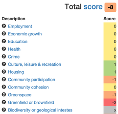
In considering sites such as the fields for allocation, Leeds City Council undertook what they call a “sustainability appraisal”. This involved scoring the fields in various categories.
Unfortunately, they made some mistakes, resulting in the site being rated in an overly positive way, while also demonstrating a lack of familiarity with the area around the fields.
When we questioned this, we were told that our comments were received outside a statutory consultation period and hence could not be acted upon. With this in mind, we present our concerns with the site scoring below (including two that we didn’t initially spot). If you wish to check the scores, (taken from an appendix to council meeting minutes1), you can see them here: Scoring for site 2062.
Note that there are some categories of scoring we simply can’t check, as the methodology for them is not public. They may have been provided by Highways, for example – as is the case for SA16: Local Needs Met Locally. The potential for further errors therein is unknown.
The specific inaccuracies we have noted with the scoring for site 2062 are in the following scoring areas:
SA04 – Health
+ All site within accessibility zone for primary health facilities (20 min walk)
O Partly within accessibility zone.
- Outside accessibility zone
This is scored 0 – partly within accessibility zone. Our score is -1 – outside accessibility zone. As far as we are aware, the closest primary care facilities are Shadwell Medical Centre and Street Lane Practice, Roundhay. Google says these are around an hour’s walk away – three times the time called for in the scoring criteria.
SA06 – Culture, leisure and recreation
Based on the location in terms of centres and therefore the proximity to cultural and leisure facilities.Consider the size of the site and impact on existing facilities.
++ Near/in the city centre
+  Near/in a town centre
O  Site not near or in a centre but
   reasonably accessible
-  Not near or in a centre
-- Loss of existing leisure facility
Site 2062 is scored as “+1 Near/in a town centre”. Our score would be “-2 Loss of existing leisure facility”. We have two questions:
Which town centre does the scorer consider Red Hall Playing Fields to be near?
How could building on the site not constitute loss of a leisure facility?
The column named “SustApprComment”
In this column the text “While not near to a centre it is within walking distance of Roundhay Park” appears. There are two problems with this statement:
It directly contradicts the score for SA06 which claims the fields are near a town centre
Roundhay Park is in no way walkable from the fields. It is around two miles away – not as the crow flies, but for a walker – over a busy ring road that has no crossing points at all on the segment that would need to be crossed. It is hikeable, but it is not walkable, for example, for my father, or for me with my four year-old daughter.
SA09 – Community cohesion
Consider the relationship of the site to the existing area, eg scale of site in relation to the scale of the existing settlement
O  Site size considered to be in scale with settlement scale
-  Site is out of scale with settlement cohesion existing settlement scale or loss of existing community facility (eg sports club, allotments)
-- Site size is considered to be significantly out of scale with settlement scale
This is scored as 0. Our score would be “-1”, losing as we would precious open space that is in practical daily use as commons and has to our knowledge been in public use since 1937. How can the scorer justify claiming there would be no loss of existing community facility?
SA10 – Greenspace
NB This score has now been corrected to -2 since our Nov 2015 consultation response. The other scores on this page are still incorrect.
++ Access to 8-9 typologies
+  Access to 6-7 typologies
O  Access to 4-5 typologies
-  Access to 2-3 typologies
-- Access to 0-1 typologies
--  Existing greenspace use on site
This is scored -1 – Access to 2-3 typologies. Our score is -2: Existing greenspace use on site. How can a scorer assert that there is no existing greenspace use when for thousands of residents this is the only amenity to which they can walk?
SA20 – Local distinctiveness
Consider scale of site in relation to existing settlement and whether it would it change the distinctiveness of the settlement.
+ Existing unattractive brownfield site
O Brownfield site, but not unattractive; greenfield site in scale with settlement; greenfield site where development could still maintain distinctiveness
- Large Greenfield site, out of character with settlement
This is scored as 0. Our score would be -1. This is a picture of the settlement it abuts: