The National Planning Policy Framework begins with twelve core planning principles.
The allocation of these fields is inconsistent with over a quarter of them.
Inconsistencies with the NPPF’s twelve principles
In general, these are the ways in which the allocation of the fields is inconsistent with the NPPF’s core principles:
1. Good standard of amenity not sought for future residents
Northern Quadrant by AceGarp
always seek to secure high quality design and a good standard of amenity for all existing and future occupants of land and buildings
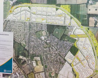
In a ward already deficient in green space, and in an area (East Leeds) that suffers from poor quality green space provision across all typologies, the plans take away valued communal green space directly opposite both an existing large settlement and the site of the Northern Quadrant (see figure, playing fields in far north-western corner). The Northern Quadrant, having planning permission, is soon to see 2000 new homes built. The site of the existing nurseries and a field to the south are set to see 300 new houses if plans go ahead. 50 houses are planned for the fields themselves.
2. Land of lesser environmental value not preferred
Allocations of land for development should prefer land of lesser environmental value
 Similar sites not being brought forward
The fields are a partly natural green space with tree cover in one corner, mature trees dotted around, and mature trees and hedgerows at the periphery. Other sites in the so-called “green wedge” extending out from Leeds are of lesser value (being only fenced green fields) and are not publicly accessible, but have not been allocated due to:
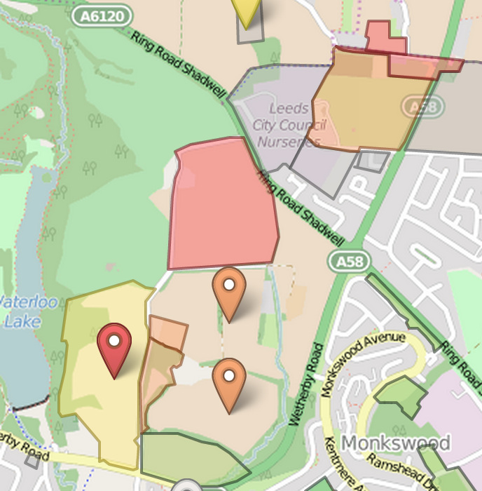
Local preference to not bring forward sites to the east of Roundhay Park (1190, 1138, 3315A, 3315B, 4013, 2063 and for Wetherby Road to remain as a natural buffer.
Site 2062 – Red Hall Playing Fields – is also a site to the east of Roundhay Park. It is also on the same side of the A58 as all these other sites where “local preference” is for the A58 to be a “natural buffer”. Whose local preference was taken into account (particularly for site 2063), and why is ours not being? Could it be because Leeds City Council hopes to realise a large capital receipt by selling the fields to developers? (The short answer, it turns out, is yes)
3. Not encouraging multiple benefits from the use of land
promote mixed use developments, and encourage multiple benefits from the use of land in urban and rural areas, recognising that some open land can perform many functions (such as for wildlife, recreation, flood risk mitigation, carbon storage, or food production)
This land is currently serving four typologies-worth of green space duty: playing provision, natural green space, parks and gardens, and amenity space, given that little else is locally accessible. See the map and search for ‘2062’ – there’s nothing else round here. It also has a wet season, which currently serves to soak up surface water that otherwise would pose a run-off risk to surrounding properties. Areas with tree cover are home to a variety of wildlife.
4. Not conserving heritage assets
conserve heritage assets in a manner appropriate to their significance, so that they can be enjoyed for their contribution to the quality of life of this and future generations
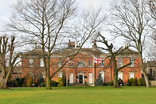
Red Hall Dec by AceGarp
No consideration we can find has been given to the preservation of the fields as the historic parkland to the grade II-listed Red Hall House.
The Town and Country Planning Act 1990 requires that “special regard” is given to the preservation of the setting of historic assets before an allocation is made. This is acknowledged in a 2013 site proforma – mirrored here when the Leeds site is down:
Redhall House to the west of this site is a Grade II Listed Building. There is a requirement in the 1990 Act that “special regard” should be had to the desirability of preserving Listed Buildings or their setting or any features of special architectural or historic interest which they possess. Consequently, before allocating this area, there would need to be some assesment of what contribution this currently undeveloped area makes to the signficance of this building and what effect its loss and subsequent development might have upon the significance of this asset. If allocated, development proposals would need to ensure that those elements which contribute to the significance of these assets (including their setting) are not likely to be harmed
We cannot find evidence of such regard.
5. Not delivering sufficient community facilities
take account of and support local strategies to improve health, social and cultural wellbeing for all, and deliver sufficient community and cultural facilities and services to meet local needs.
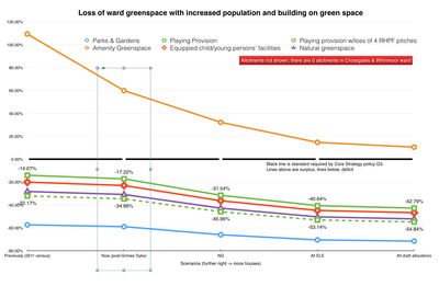
At ward level, we are already in deficit in five out of six typologies of green space. Locally, this is the single public amenity/common space in walking distance. Moving the majority of the fields to a different ward is unacceptable in both the NPPF and in Leeds’ own core strategy policy G3.
We are well below acceptable accessible green space standards in our ward. Even if the fields were to remain, building is going to push us further into unacceptable deficit. We should not be allocating these fields for development, as this would further exacerbate an already bad situation. We are already due to lose a large proportion of this land to the East Leeds Orbital Road. Let’s not make it any worse.
It appears Leeds’ response to this is to play down their own ward-based green space analysis, and that we should use Roundhay Park. Roundhay Park is not – in any typology for which it is used – within the accessibility distances called for in Core Strategy Policy G3. It’s also on the other side of a Ring Road with no crossing points, and no entrance on the side of the Ring Road. Into some woods.
Specific, detailed NPPF inconsistencies
Section 8, paragraph 70
To deliver the social, recreational and cultural facilities and services the community needs, planning policies and decisions should:
- plan positively for the provision and use of shared space, community facilities (such as local shops, meeting places, sports venues, cultural buildings, public houses and places of worship) and other local services to enhance the sustainability of communities and residential environments;
- guard against the unnecessary loss of valued facilities and services, particularly where this would reduce the community’s ability to meet its day-to-day needs;
For hundreds of houses east and west of the A58, this is the only amenity within walking distance.
We are about to see construction of the East Leeds Orbital Road (ELOR), which will leave this block of residential developments bounded by three major roads: the A58, the A6120 outer ring road, and ELOR.
Their planned reduction in size to accommodate 50 more houses when thousands of houses are being built both east and west of them reduces our ability to meet our day-to-day needs. There is an opportunity in this location to make a distinctive place that serves its residents well and includes Red Hall House as an historic centrepiece. That opportunity is being squandered.
- ensure that established shops, facilities and services are able to develop and modernise in a way that is sustainable, and retained for the benefit of the community;
One planner has remarked to us that this is one of the least sustainable uses of land he has seen in the entire allocations process. We will be much less able to meet day-to-day needs surrounded by A-roads.
- ensure an integrated approach to considering the location of housing, economic uses and community facilities and services.
This allocation can in no way be considered an “integrated approach”. For the sake of 50 houses, it utterly ignores the huge incoming developments to both its east (Northern Quadrant, 2000 houses) and west (soon-to-be-vacated brownfield Council nurseries and annexed greenfield, some hundreds of houses), and likewise pays no heed to the further deficits in green space into which this ward will be forced.
It is not possible to say how much green space will show up in compensatory form. When this land is sold, that will be left to developers, who, as councillors have already said, have the whip hand in terms of monetary and legal resources when it comes to winning planning appeals. The worry is that this part of Leeds will become another endless stretch of car-dependent houses with few facilities and little infrastructure.
Section 8, paragraph 73
Access to high quality open spaces and opportunities for sport and recreation can make an important contribution to the health and well-being of communities. Planning policies should be based on robust and up-to-date assessments of the needs for open space, sports and recreation facilities and opportunities for new provision. The assessments should identify specific needs and quantitative or qualitative deficits or surpluses of open space, sports and recreational facilities in the local area. Information gained from the assessments should be used to determine what open space, sports and recreational provision is required.
Our green space deficit and projected further fall should be all the evidence that is required to show that the retention of as much of this space as possible should be an absolute requirement. These fields are serving multiple purposes: they are our playing provision, our amenity space, our parks and gardens, and our natural green space. There is nothing in those latter three categories in the walkable distances defined in core strategy policy G3.
Section 8, paragraph 74
Existing open space, sports and recreational buildings and land, including playing fields, should not be built on unless:
- an assessment has been undertaken which has clearly shown the open space, buildings or land to be surplus to requirements; or
We cannot find such an assessment.
- the loss resulting from the proposed development would be replaced by equivalent or better provision in terms of quantity and quality in a suitable location; or
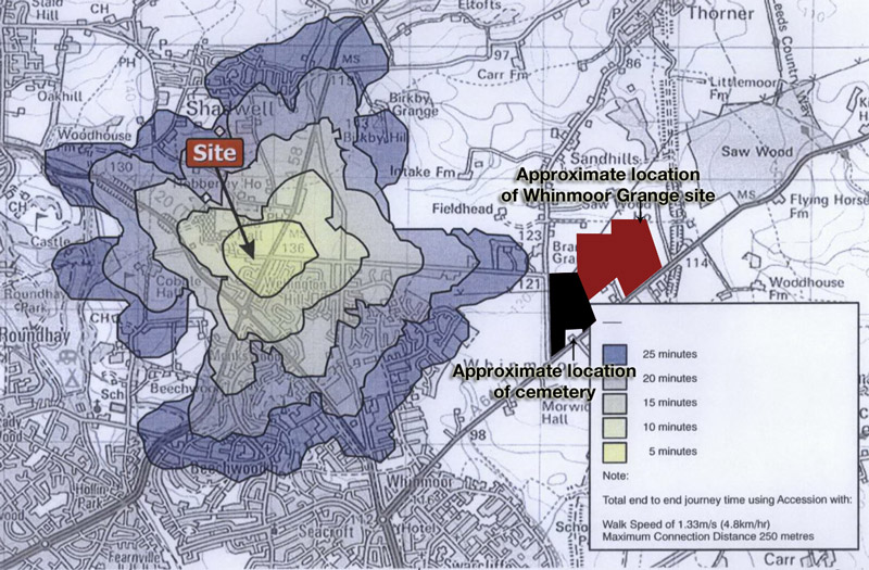
The planned replacement is not in the same ward; it would transfer hectares of publicly-accessible green space to the Harewood ward, which already enjoys a surplus; that new facility would not be near the majority of Red Hall / Whinmoor residents and would require a car journey to get to. It would also be sited adjacent to a cemetery. It seems scarcely appropriate that mourners, in their grief, might have the noise and robust language of Sunday League games happening next door to them, while Red Hall House, which houses a sporting body in the shape of the Rugby Football League – and whose pitches are used to train referees – will see a dual carriageway and housing.
- the development is for alternative sports and recreational provision, the needs for which clearly outweigh the loss.
The development would be for more housing and a dual carriageway, with all the attendant traffic, pollution and noise that would bring.
Section 11, paragraph 110
In preparing plans to meet development needs, the aim should be to minimise pollution and other adverse effects on the local and natural environment. Plans should allocate land with the least environmental or amenity value, where consistent with other policies in this Framework.
As we state above, land of lesser amenity value is to be preserved. Adverse effects on air and noise will come from the 50mph dual carriageway East Leeds Orbital Road.
Section 11, paragraph 123
Planning policies and decisions should aim to: […]
- identify and protect areas of tranquillity which have remained relatively undisturbed by noise and are prized for their recreational and amenity value for this reason.
Towards Red Hall House, the noise from the A58 is not particularly noticeable. Houses at that end have normal windows. However, new houses nearer the A58 are triple-glazed and have venting in different areas to prevent the ingress of noise. The plans to cut these fields in half with a dual carriageway – and further, only to dig that road to a metre’s depth – will destroy the quieter nature of the west of the fields and create 24-hour noise for everyone in the vicinity.
Section 12, paragraph 126
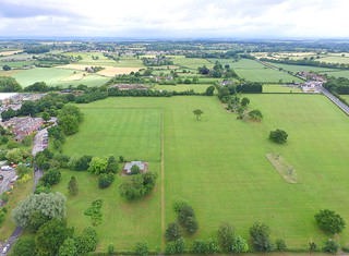
Overview 3 by AceGarp
Local planning authorities should set out in their Local Plan a positive strategy for the conservation and enjoyment of the historic environment, including heritage assets most at risk through neglect, decay or other threats. In doing so, they should recognise that heritage assets are an irreplaceable resource and conserve them in a manner appropriate to their significance. In developing this strategy, local planning authorities should take into account:
- the desirability of sustaining and enhancing the significance of heritage assets and putting them to viable uses consistent with their conservation;
- the wider social, cultural, economic and environmental benefits that conservation of the historic environment can bring;
- the desirability of new development making a positive contribution to local character and distinctiveness; and
- opportunities to draw on the contribution made by the historic environment to the character of a place.
So far, as we have said, there has been no “special regard” given to Red Hall House or its setting according to the Town and Country Planning Act 1990. This allocation also runs counter to paragraph 126 of the NPPF.
The house was once a hunting lodge and the fields part of the house’s curtilage. There is long history here of sporting activity. The fields were sold to Leeds City Council in 1937, and while originally intended for a velodrome, they were used for many years for sporting activity – football, cricket and rugby. The house itself is now home to the Rugby Football League. Many residents local to the fields talk of their experiences growing up playing formal and informal games on the fields, and express shock at their potential loss.
The local character and distinctiveness here are bound up in the history of the house and its associated land for sporting endeavour and recreation. In allocating this site these are all factors Leeds City Council is choosing to overlook.

